FSCSP: Hydrogeology Qestions
FSCSP: Hydrogeology Qestions |
| Hydrogeology Home Page |
The primary question following the discovery of Snowy River in 2001 has been “Where, when and how does Snowy River flow?” Obviously the surface water from Sierra Blanca and surrounding areas “leak” into the local aquifers, and the FSCSP has been evolving a flow analysis related to the USGS #08387600 Eagle Creek gauging station and other detail information in the cave.
|
||
 |
||
QUESTIONS: Where does the water come from when Snowy River flows? That was the first question which we can now answer: Eagle Creek Area. |
| 1) What is the source of the flooding in various locations in the cave? |
| 2) What is the paleohydrology of the cave? How is it associated with the entrance? |
| 3) To what extent does Snowy River flood partially, never reaching Turtle Junction? |
| 4) What additional monitoring tools will best serve us to document the hydrology of the cave? |
| 5) How long does it take for the saturated Snowy River deposit to firm up after a flood event? |
| 6) What water chemistry and environment accounts for the calcite deposition? |
| 7) What are the real and possible contamination issues? |
| 8) What water tracing mechanisms can be safely used in Snowy River? |
| 9) What caused the transition in Snowy River from clastic deposition (gravel, sand, mud) to chemical deposition (calcite)? |
| 10) Was this transition direct, or was there a hiatus during which flow through the conduit was inactive? (Answerable by cosmogenic radionuclide dating of clastic sediment.) |
| 11) What limits the maximum flow of Snowy River when it is active? |
| 12) What is the role of present and past atmospheric factors (CO2 degassing, evaporation / condensation) in the deposition and dissolution of calcite in the Snowy River complex? |
| 13) How is evidence of other flow events in the cave related to the Snowy River time line? (How are the waterlines related?) |
| 14) How many external sources of water are there, and where are they located? |
| 15) What is the best software to model the complex hydrology of Fort Stanton Cave? |
| 16) Where is the best location to remotely obtain real-time water level data so that it can better predict Snowy River flows? |
| 17) To what extent is there hidden water flow under the calcite surface of Snowy River? The Main Corridor? |
| 18) Can we determine if there is any modern flow at the Sand Boil in Sandy River? What is the date of the carbon collected there? |
| 19) Are there water sources in addition to Snowy River that feed Crystal Creek? |
| 20) Are there additional sources that feed other resurgences near Government Spring? |
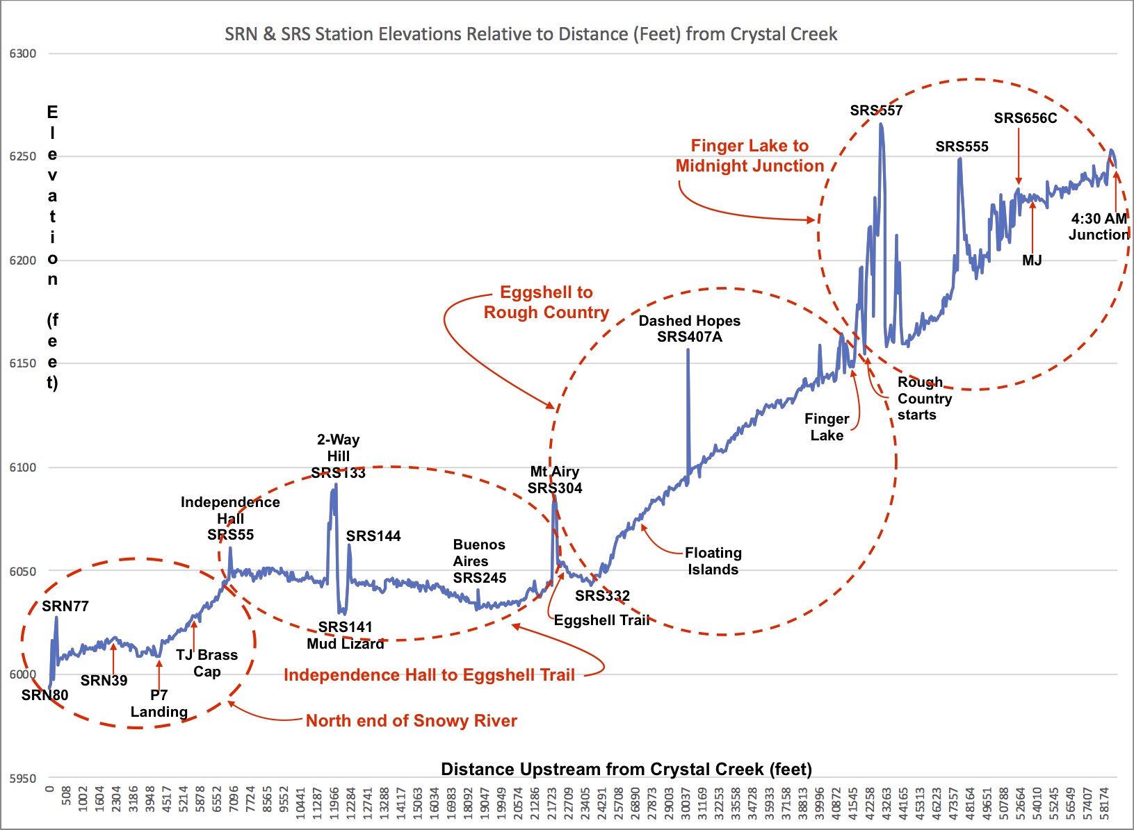
| 21) What are the relative elevations of the data logger locations? |
| 22) How does the Rio Bonito impact the hydrology of Fort Stanton Cave? |
| 23) Is there a void space under Snowy River, and if so, how does it relate to water above the Snowy River calcite surface? |
| 24) Why does the Snowy River calcite deposition rapidly disappear before Crystal Creek? |
| 25) Why is there no travertine deposition at Government Spring? (Is it because the Snowy River formation is not normal travertine?) |
| 26) Where does the water come from in the Pure Intentions section of the PA survey? |
| 27) Does the "upper stretch" of Little Creek (above the sewage plant) contribute any water to the Midnight Junction area? Do the apparent "fractures" in the floor of Little Creek below the possible "insurgence pool" contribute? |
| 28) Can we identify any "recent" flow (last 9 years) through the Sand Boil in the Sandy River side passage? |
Rev. 2-27-2023 |
Comments to the webmaster |
Contact the FSCSP President |
Contact the Project Director |