Hydrogeology Home Page
Hydrogeology Home Page |
Where does the water come from when Snowy River flows? That is the main question ... |
||
|
||
Introduction and Goals of the Hydrogeology Group (stay tuned) |
|
|
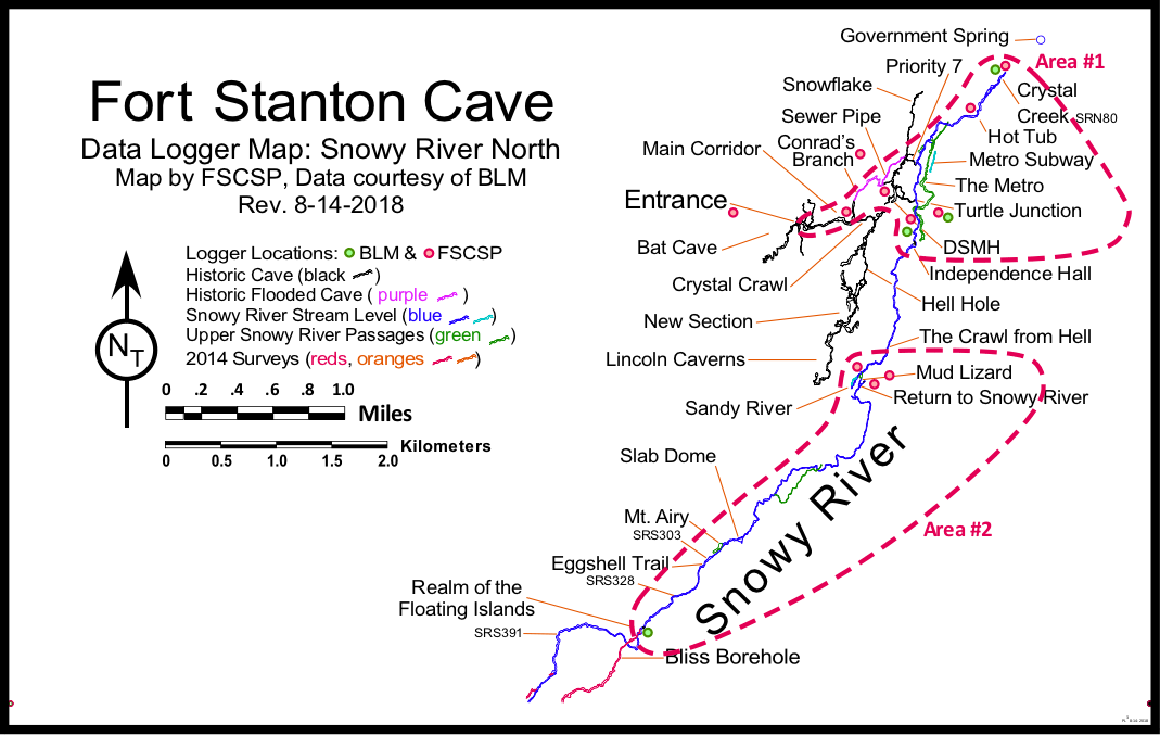
After a challenging breakdown route connection through Priority 7, which followed a significant airflow through tiny spaces, Snowy River was discovered in 2001. The calcite crystal floor was delicate, and it was dry. Two years later, after the EIS paperwork was finished, cavers returned and explored the passage downstream to the north, where the passage ended in a large room named Lincoln's Bathtub, and a small passage continued under the water of Crystal Lake, fed by tiny Crystal Creek. |
2001 |
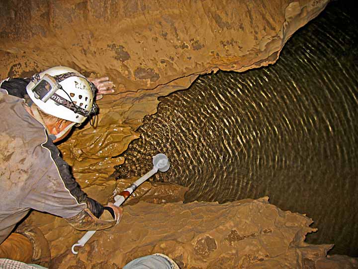
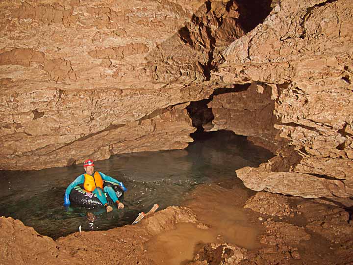
Michael McGee dipping water from Crystal Creek in 2008. |
Heading upstream to the south, cavers were excited to find that the mostly walking passage continued for over a mile, and they also surveyed a side passage they named Mud Turtle. It ended under a large breakdown room which was discovered in 1971. An ambitious project to dig a 44 foot connecting shaft was approved, and after two years, with help from 200 volunteers, the Access Portal was constructed, giving caver-scientists a safer access to Snowy River. Cavers were surprised to find Snowy River silently flowing with clear, cool water. |
2007 |
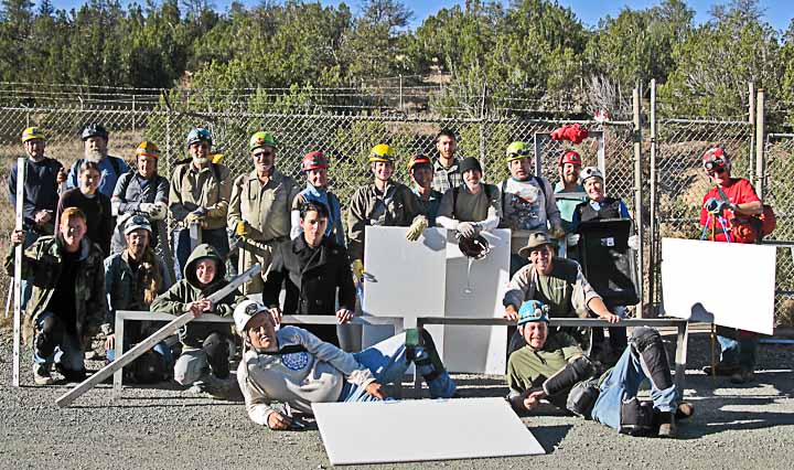
Volunteers constructing the Access Portal in Don Sawyer Memorial Hall prepare to carry in another load of materials. |
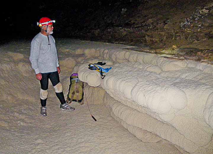
After several hurried attempts to measure the water flow with home-made data loggers, we installed a small professional Schlumberger water logger with the associated barometer unit at Turtle Junction. The baro unit allowed a more precise calibration of the adjacent pressure-sensitive water logger which was positioned in about 14 inches of water. Future (2018) plans include measuring precise elevations and cross sections in several locations where loggers are currently installed. This data, plus an actual Turtle Junction flow measurement during a future Snowy River flow, will provide new data for an overall hydrology model. |
2008 |
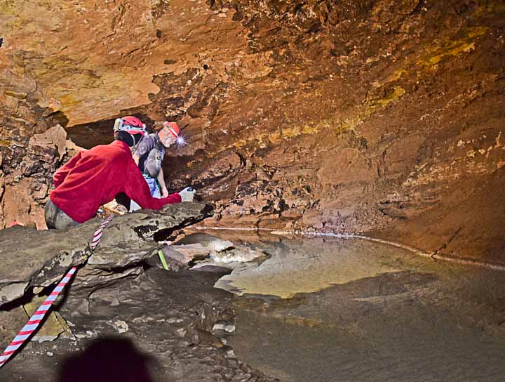
Turtle Junction offers the best location for hydrological monitoring data during actual Snowy River flows. |
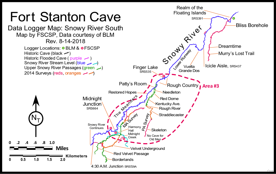
After a 9-month flow at Turtle Junction, the first data logger record was recovered. It appeared that the flow at Turtle Junction started about 72 hours after a heavy rainfall at nearby Ruidoso Airport, at which time exploration of Snowy River South had not quite reached that point under the surface. Soon after, the hydrology mapping of Snowy River continued to a point just beyond Eggshell Trail. Exploration stopped again, awaiting a decision to continue over this short section where the calcite surface was so thin it broke, revealing a layer of mud below. During the initial trade study for future loggers, it was decided that baro units would be placed at both Turtle Junction and Midnight Junction. |
2010 |
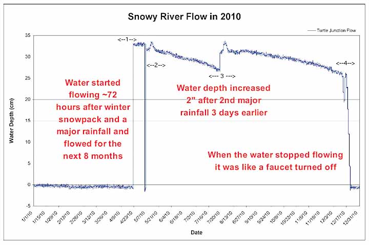
1st flow diagram from the 3rd observed Snowy River flow at Turtle Junction correlates with surface rains. |
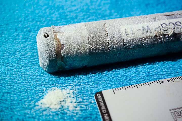
Realizing that more precise data logging would be required to determine the relationship of Snowy River flows to the surface above, a trade study was started to identify the best logger units to place deeper in the cave that could help understand the hydrology of this unique passage. A BLM-led team of "Strong and Light" cavers was able to make it back to Eggshell Trail where they placed a Solinst logger (with Baro) at a new location they named Floating Islands. The new requirements for S&L cavers would require day trip durations greater than 30 hours to continue explorations, and any loggers carried in their full packs would have to be small and at the same time last more than 5 years. Data loggers with short battery life or requiring external wires or vent tubes would not be appropriate An additional logger would be placed at a low, muddy area called Mud Lizard to determine to what extent this possible sump in Snowy River would actually flood to the ceiling during the expected 9-month flow during a rainy season. Loggers were also placed both upstream and downstream from the Mud Lizard location to evaluate the timing for a future flood to propagate through the breakdown blockage. Data loggers placed at the Turtle Junction and Plunge Pool locations were maintained during parts of the 2014 flood, and were noted to collect a surprising amount of calcite coating at this location. Mike Spilde has tile samples at both locations to gather calcite deposition data of the calcite loaded water. |
2012 |
In-Situ loggers deployed at Turtle Junction were covered with calcite when retrieved. |
Choosing In-situ Troll 100 loggers for the deep deployment in the cave, units were placed far north at Crystal Creek, a deep pool at station SRN53, Turtle Junction and the near-by Plunge Pool, at SRS53 just north of Independence Hall, and 3 locations near Mud Lizard. The explorers were excited to find a water source which they called Finger Lake. Soon, the hydrology survey had continued 9 miles south of Turtle Junction to a possible Midnight Junction camp site, at a point where numerous side passages intercepted the on-going Snowy River. Additional water loggers were deployed at Finger Lake, the continuing Snowy River and Midnight Creek. Baro units were deployed at Midnight Junction and Turtle Junction. |
2013 |
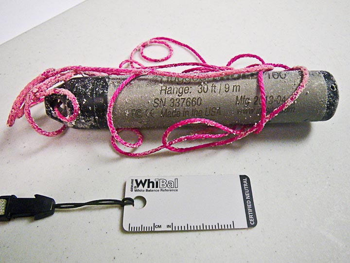
This logger was deployed at the Plunge Pool in 2013, along with other units deployed over 10 miles of Snowy River. |
In August 2014 a science team heading towards Midnight Junction encountered slowly flowing water at survey station SRS390 and made a quick exit. That flow front never reached Turtle Junction. But another flow front arrived at Turtle Junction a month later and continued for two years. This flow was the 4th recorded flow event of Snowy River. Rainfall following the Little Bear Fire in Ruidoso caused major flooding of the Rio Bonito, and was also likely the cause of extended Snowy River flows. |
2014 |
The start of a 4-year Snowy River flood was the 4th recorded flood event. |
Main Corridor loggers were installed, in hopes of future correlation with Snowy River flows. There are numerous historical reports of flooding in the Main Corridor over the past 150 years. The photo at the right is at the entrance to Sewer Pipe, which is very muddy when not flooded, and was once the only connection with Snowflake Passage. This location is called Sewer Pipe Landing, and is along the route to the new Access Portal and Turtle Junction. So far we have not proved a connection with this water system and Snowy River, although a dye trace was achieved from the Rio Bonito to the Main Corridor in 1983. A month after the 2014 flow ended, a 5th flow was observed at Turtle Junction that lasted 4 months, shortly followed by a 6th flow that ended in August 2017. |
2016 |
Conrad's Branch in the Main Corridor was flooded during the 2014 Snowy River flow. A logger was installed here in 7 feet of water. |
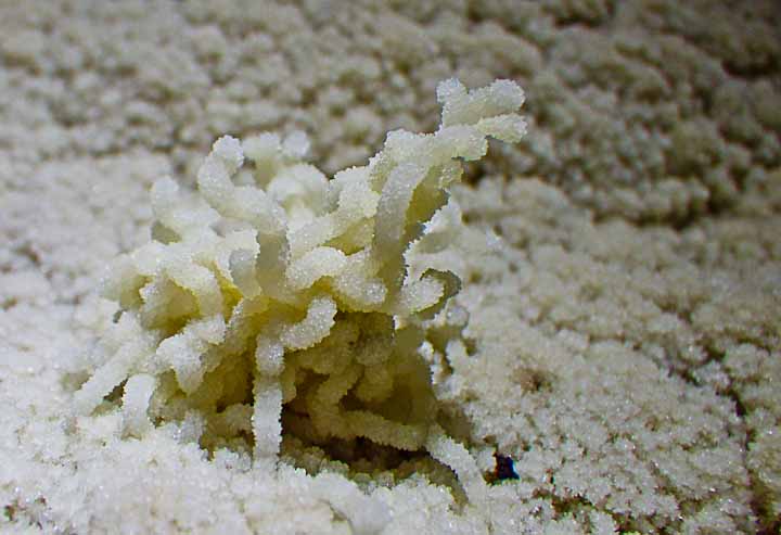
A 7th flow was observed at Turtle Junction that lasted another 3 months, ending in April 2018. When the loggers in the Turtle Junction area were serviced in 2017 and 2018, some "new" calcite formations were observed on the floor of Snowy River and initially were called "Snowy River worms or straws". These formations were first observed and later named "detrituscite" by Knutt Peterson (dee-tri-tus-site). They apparently are formed around small bits of "detritus", shed from cavers during travel on Snowy River. Some of the materials that make up this detritus which serve as the core of these new formations are rubber, thread, lint, and human hair. Rubber comes from the soles of shoes, threads of material and lint come off of packs and clothing, and human hair is shed from the caver. These materials are deposited on the dry floor of Snowy River during travel. When there is water flow on Snowy River, which is generally saturated with calcite, these materials serve as a surface for the deposition of calcite. During extended flow events, there is sufficient time for the buildup of calcite on these objects to become noticeable, and thus observed. Crystal Spring and Hot Tub loggers were retrieved in July 2018 during a trip to evaluate the hardness of the calcite floor of Snowy River, after 4 years of almost constant water flow. |
2018 |
Calcite formed a "straw" around a human hair "skeleton" |
 |
||
 |
||
|
A new FSCSP publication that summarizes the data logger work for more than a decade after the world class Snowy River discovery is now available. A Decade of Data Logging in Fort Stanton Cave and Snowy River covers the majority of data logging in the cave and Snowy River. This is a 35 MB download of a 139 page pdf file published as a Fort Stanton Cave Study Project report on March 30, 2021. This is still a work-in-progress as future editions will include additional data logger data from 2021 plus comments and references from numerous hydrogeologists and other interested scientists and cavers that are all part of our team of volunteers and supporting agencies. |
||
Rev. 2-19-2023 |
Comments to the webmaster |
Contact the FSCSP President |
Contact the Project Director |